On November 4th, the City of Corvallis held a public open house on the ongoing Safe Streets for All project (SS4A). The Crier’s Junior Editor visited the open house to report on some of the proposed changes to our roadways.
The SS4A Project is a federally funded effort that aims to make roadways safer for all users, especially vulnerable road users. The goal is to reduce crashes that result in serious injury or fatalities. Corvallis was a recipient of this project and has a city-led task force to work on the implementation of the project. Right now, Corvallis is developing a long-range Transportation Safety Action Plan that identifies high-risk, high-crash areas in the city with recommendations on how to improve them.
The city has hired a consulting team to work on this project. It is composed of transportation engineers and professionals from DKS Associates, Toole Design, and JLA Public Involvement. DKS is responsible for the hardcore engineering and design aspect. Toole focuses on analyzing the crash data, while JLA Public Involvement, as the name suggests, is responsible for public outreach.
The project will focus on improving both city roads, managed by Public Works, and county roads, managed by Benton County. To see the full list and give feedback on the recommendations, visit the online Open House on Corvallisoregon.gov by November 25th.
In the Open House, the consulting team made several recommendations to the City of Corvallis and the public on certain intersections and road sections to prioritize reducing crash data. This is consistent with Vision Zero, the goal to reduce all roadway deaths, which is also a part of the city’s comprehensive traffic plan adopted by the City Council in 2020, and Oregon’s current Transportation Safety Action Plan.
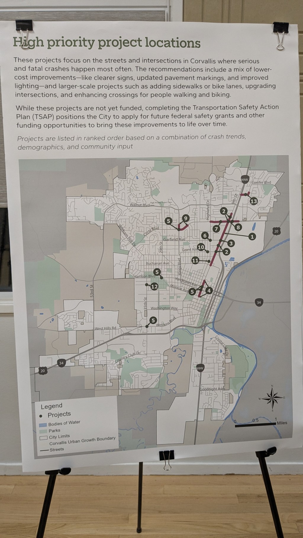
Many of the recommendations were concentrated in East Corvallis with a focus on improvements along 9th Street. The map shown shows each location that the consulting team recommended for improvements, and in order of priority. Vice President of DKS, John Bosket, was surprised by the number of projects that were concentrated in one area of Corvallis. However, he stressed that this project serves as a recommendation and a next steps vision board for the city in terms of trying to reduce the overall crashes and target specific, highest crash locations. For more detailed information on each site-specific location, such as crash data, existing problems and conditions, and proposed recommendations, visit the online Open House through the Corvallisoregon.gov website on the Safe Streets For All Page till November 25th.
Talking with Corvallis Transportation Division Manager Rory Rowan about the next steps of the project, Rowan mentioned the challenges associated with funding. He emphasized that all these locations and proposed improvements were merely recommendations to the city by the consulting team. It is not guaranteed that the city will do all of the projects listed. He also mentioned that the point of the program was to develop the city’s long-range Transportation Safety Action Plan. When asked why, Transportation Division Manager Rory Rowan focused on the challenges of obtaining funding for these projects. With many of these improvements costing hundreds of thousands of dollars, the biggest factor in the implementation of these safety improvements is the ability to pay for the project. Talking with a JLA Public Involvement representative, she mentioned that the hope is to have all of these suggestions incorporated into the city’s TSAP, and that the transportation division will present it to the City Council around next Spring.
When looking through the projects, many other community members who attended the open house talked about other locations they feel are unsafe. Rory Rowan mentioned the City’s new “Report a Problem with Corvallis Connect” found on the city’s website. He said that if any community members would like the city to look into changing the design of specific roads or intersections in the city, fill out the Report A Problem form under the Traffic Control Change Request Section. However, he again stressed that any projects were dependent on funding.
When asked about bike lane improvements, such as upgrading our buffered bike lanes to protected bike lanes through flex posts, Rowan said that the biggest challenge was the maintenance of the bike lanes, as the city will need narrow Road Sweepers to clean any leaves or debris from the bike lane due to the presence of the flex post or concrete buffer. However, Rowan mentioned that the city has gotten a grant to purchase an electric sweeper specifically for those situations and said that the residents may see more protected bike lanes in the future!
Another component of the SS4A project is the Walnut Feasibility Lane Evaluation Study. Here, Corvallis Public Works Project Manager Adam Steele and Public Works Assistant Director Ahmad Qayoumi were taking questions from the community, who were curious about the study. To summarize, the city conducted a feasibility study on Walnut Blvd from Witham Hill/Glenridge to Jack London Ave in the East to see if they could go from 4-5 lanes and reduce it to 3 lanes total. This reduction is known as a road diet and features one lane in each direction with a center turning lane with buffered bike lanes. Converting to 3 lanes slows drivers down and reduces lane switching, which can decrease crashes by 29% and bike-related crashes by 43%.
To my surprise and many other community members, the study showed that it was feasible for Walnut Blvd to undergo a conversion from 4-3 lanes throughout the entire stretch, except for the intersection at Highland Dr.
The informational poster mentioned that it would only cause a 30-45 second delay when travelling from one end to the other. However, public works project manager Adam Steele emphasized that this was just a thought experiment to see if this was possible. Nothing is actually going to happen. To calm any fears about this happening, on the city’s website, it states that, “This study was intended to inform future conversations about how Walnut Boulevard could evolve to better balance safety and mobility for everyone. No decisions have been made, and further community discussion would be needed before any design changes are considered.”
Talking more with Steele, he mentioned how he wanted the city to have more data before doing a major lane reduction. He specifically mentioned the Safer Circle project done a couple of years ago, where the city piloted a road diet that has now become permanent, and how he wanted more data to be collected regarding the feasibility before doing something similar on Walnut Blvd.
A community member there mentioned her dislike of roundabouts and hoped that it wouldn’t be implemented. She reminisced on the annoyance of the now-removed mini traffic circle, not a roundabout, on Highland and Garfield. However, if the city were to do a lane reduction on Walnut Blvd, roundabouts would minimize the impacts of increased traffic congestion. This is because of some semi-simple traffic engineering concepts of vehicle platooning and traffic lights. However, Steele continued to say that funding would be a major challenge in any of these projects. Yet, any lane reductions on Walnut are most likely going to generate significant community pushback.
A community member, Rob Upson, on the other hand, has a theory on why the feasibility study worked out in favor of a lane reduction. Upson mentioned that the city has a tool to determine its tolerance of congestion on roadways. He believed that currently, the city’s congestion is around a B grade. But the city is willing to endure congestion until it goes to a D Grade, which is why the feasibility study, though it will increase travel times, has said yes to the lane reduction. Upson also expressed the hope that at least part of Walnut will see a lane reduction in the future to increase road safety.
However, in our discussion, we mentioned the closure of Letitia Carson, causing more drivers to drive east to Bessie Coleman and congesting the Walnut and Aspen intersection as drivers are trying to make left turns. Since there are no dedicated left-turn lanes or a protective left-turn phase, congestion is expected to increase during morning hours on Walnut Blvd. This might be the push from community members to implement a road diet between Witham Hill/Glenridge and 29th St on Walnut Blvd.
To learn more about the feasibility study, visit the online open house on the City website.
Finally, I spoke with Ted Reese, the Transportation Engineering Supervisor at the City of Corvallis, about the condition of our traffic signals. He mentioned that the city has 42 signalized intersections, and about half of them are due for replacement. But again, the city doesn’t have funds to replace them. Now, many of them are extremely old and use old tech, and there’s a strong possibility that the traffic lights may break down suddenly. A traffic light has a 50-year life span. He mentioned how in the 1970s, HP Corvallis brought many jobs to the town, resulting in the city installing many traffic lights. Now, 50 years later, all of our traffic lights are wearing out their life span at the same time, and it is proving a challenge to deal with this issue. Reese then talked about how he has a maintenance budget every year, and if he has any surplus, he’ll use it to fund safety upgrades across the city. Lastly, an interesting local transportation fact Ted mentioned was how many of our signals behaved differently throughout the day. Discussing specifically at Walnut and Highland, Reese, who works on programming many of our traffic signals, said that this traffic light is programmed so that at the start and end of school, the green light maximum time is increased to allow for more cars to pass through the intersection. So when all of the CV students go and leave school, the maximum amount of time the green light can stay green is increased compared to the rest of the day.
As the city of Corvallis continues to balance growth, safety, and efficiency, the SS4A project and the resulting recommendations serve as a reminder and a roadmap to the city and the public of the city’s commitment to make Corvallis’ transportation network safer for all road users. While many of the proposed improvements lack funding for their implementation, their integration into the TSAP and the CIP will both be used to inform and guide the decision-making process for future projects. Expect to see many of these improvements and recommendations coming to fruition in the near future. To learn more about the project and provide feedback, visit the SS4A page at corvallisoregon.gov